Western Alaska Minerals Waterpump Creek Drilling Intersects 16.7 Meters Of Oxide Mineralization Grading 484 G/T AGEQ
Jan 18, 2022
![]()
TUCSON, ARIZONA, US – January 18, 2022 - Western Alaska Minerals Corp. (the "Company" or "WAM") (TSXV: “WAM”) is pleased to announce the final 2021 drill results from the Waterpump Creek carbonate replacement deposit (“CRD”) target at its 100%-owned Illinois Creek project in western Alaska. Additional assays are pending from 2021 drilling at the Honker high grade gold target and the Last Hurrah CRD prospect.
Highlights
- Nine drill holes totaling 851 meters were completed at Waterpump Creek, targeting both shallow high-grade oxide mineralization and deeper high-grade sulfide mineralization.
- The oxide-focused drill results demonstrate an open 500 by 200+ meter wide manto of Ag, Pb, Zn CRD mineralization developed at or near a shallow east-dipping thrust contact between a thick dolomite and overlying schists.
- WAM completed its first test of sulfide mineralization (WPC21-09) below the oxide cap in primary sulfide mineralization which demonstrated exceptional high-grade sulfide mineralization that is open down dip and to the north and south.
- Notable intercepts:
- WPC21-02 - 484 g/t silver equivalent (AgEq) (256 g/t silver, 6.4 % lead and 0.7 % zinc) over 16.7 meters from 23.2m which includes a 3.0 meter intercept of 1094 g/t Ag, 27.4% Pb and 0.3% Zn between 23.2 and 26.2 meters,
- WPC21-03 - 584 g/t silver equivalent (AgEq) (89 g/t silver, 7.7% lead and 6.3% zinc) over 9.7 meters from 63.1m and 1337 g/t Ag over 1.5 meters with nil Pb and Zn from 50.9 and 52.4 meters,
- WPC21-09 (Previously Released) - 1886 g/t silver equivalent (AgEq) (522 g/t silver, 14.5% lead and 22.5% zinc) over 10.5 meters from 109.4m.
“Exploration at Waterpump Creek in 2021 focused on expanding our understanding of the high-grade manto mineralization first discovered by Anaconda Minerals Co. in the early 1980’s” commented CEO and President Kit Marrs. “Because CRD’s are known for their exceptionally long continuity, large high-grade resource potential, and often stacked nature of mineralization, 2022 exploration at Waterpump Creek will focus on expanding the high-grade mineralization identified in WPC21-09 and the continued testing of the Waterpump Creek Fault/Last Hurrah trend south of Waterpump Creek” Mr. Marrs added.
2021 Waterpump Creek Drill Results
Table 1 summarizes the results from the 2021 drilling, the first drilling in over 15 years on the Waterpump Creek target.
| Drill hole | From
(meters) |
To
(meters) |
Thickness
(meters) |
True Thickness (meters) | Ag
g/t |
Pb
% |
Zn
% |
Ag Eq
g/t*** |
| WPC21-01 | 21.5 | 32.4 | 7.4
(3.1 NR*) |
7.4 | 20 | 0.4 | 2.5 | 134 |
| WPC21-02 | 23.2 | 39.9 | 16.7 | 15.7 | 256 | 6.4 | 0.7 | 484 |
| including | 23.2 | 26.2 | 3.0 | 2.8 | 1094 | 27.4 | 0.3 | 1960 |
| 36.9 | 39.9 | 3.0 | 2.8 | 287 | 2.1 | 2.8 | 466 | |
| WPC21-03 | 50.9 | 52.4 | 1.5 | 1.4 | 1337 | nil | nil | 1337 |
| 63.1 | 75.6 | 9.7
(2.8 NR*) |
9.1 | 89 | 7.7 | 6.3 | 584 | |
| WPC21-04 | 64.9 | 71.2 | 6.3 | 5.9 | 76 | nil | 5.2 | 283 |
| including | 64.9 | 66.4 | 1.5 | 1.4 | 315 | nil | 0.5 | 335 |
| WPC21-05 | 35.6 | 50.9 | 11.9
(3.4 NR*) |
11.2 | 149 | nil | 2.0 | 230 |
| including | 35.6 | 39.0 | 3.4 | 3.2 | 507 | nil | 0.4 | 523 |
| WPC21-06 | 119.7 | 122.8 | 3.1 | 2.9 | 8 | 0.4 | 2.5 | 122 |
| WPC21-07 | FW only | |||||||
| WPC21-08 | Lost In HW | |||||||
| WPC21-09** | 109.4 | 120.9 | 10.5 (1.0 NR*) | 9.1 | 522 | 14.5 | 22.5 | 1886 |
* NR- No Sample Recovery
** Restated with additional assays to those previously released
*** Ag Equivalencies based on spot prices of $22/oz Ag, $1.00/lb Pb, and $1.30/lb Zn
2022 Plans at Waterpump Creek
The Company’s technical team, led by Chief Exploration Officer Joe Piekenbrock, in consultation with WAM Technical Advisor and world-renown CRD expert, Dr. Peter Megaw and WAM Technical Advisor Darwin Green, is currently designing a geophysical program to help define the 2022 drill targets down dip from WPC21-09 and the targets along the highly prospective 5 km trend that extends from Waterpump Creek to Last Hurrah and Illinois Creek.
The 2021 drill results demonstrate an open 500 m by 200+ meter-wide manto of Ag, Pb, Zn CRD mineralization developed at or near the shallow east-dipping thrust contact between a thick dolomite and overlying schists.
Figure 1 shows a plan map of the Waterpump Creek manto and contoured contained metal expressed as a function of grade (grams/tonne AgEq) x the width of the mineralized interval. The geology is characterized by a thrust plate of quartz chlorite muscovite graphitic schist overlying a thick section of Ordovician dolomite. A flexure on the thrust surface characterized by a steepening of the thrust contact to greater than 30 degrees looks to control both the transition from oxide to sulfide mineralization as well a strengthening of the grade and thickness of the sulfide mineralization.
Figure 1. Grade x Thickness Map (AgEq gpt x meters) at Waterpump Creek
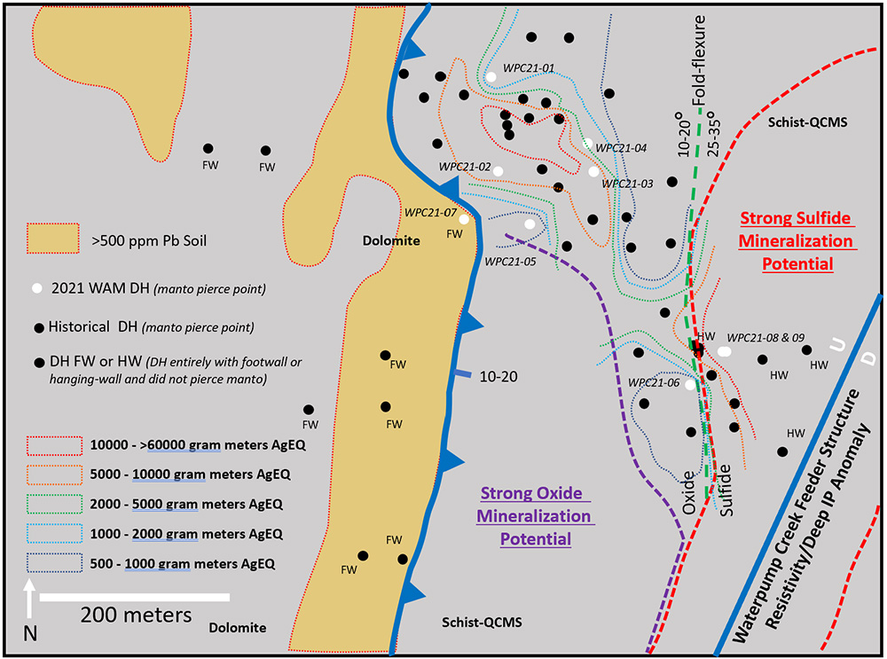
* Grade x thickness intervals are based on a minimum $50/tonne gross metal value and spot metal prices of $22/oz Ag, $1.00/lb Pb, and $1.30/lb Zn
As expected, oxidized Pb, Zn and Ag mineralization is highly variable across the mineralized gossan evaluated in the 2021 drilling. True thickness varies from as much as 15.7 meters to as little as 2.9 meters. Historical drilling in the oxidized mineralization includes some impressive intervals including NovaGold’s KH05-01 which returned 19.6 meters of 478 g/t Ag, 26.6% Pb and 5.4% Zn.
The drilling demonstrates that significant Ag oxide mineralization exists at very shallow depths which may be amenable to vat leach extraction (currently being studied for the Illinois Creek oxide Au/Ag resource). WPC21-07, the last of the targeted oxide holes drilled below the mineralized manto in the footwall (“FW”) dolomite sequence. Significant potential to expand the oxide mineralization occurs to the south and is defined by a continuous 500 ppm Pb soil anomaly extending 600 meters further to the south.
As previously mentioned, the 2021 drilling at Waterpump Creek included WAM’s initial test of sulfide mineralization below the oxide cap in primary sulfide mineralization. A few of the historic drill holes by Anaconda and NovaGold had encountered very high-grade primary Ag, Pb, Zn sulfide mineralization shown in Table 2.
Table 2. Historic Sulfide Intercepts Waterpump Creek
| Drill hole | From
(meters) |
To
(meters) |
Thickness
(meters) |
True Thickness (meters) | Ag
g/t |
Pb
% |
Zn
% |
Ag Eq g/t |
| WPC84-027 | 107.3 | 115.1 | 7.8 | 6.8 | 771 | 9.8 | 10.5 | 1402 |
| WPC84-031 | 124.4 | 135.0 | 10.6 | 9.2 | 289 | 10.1 | 12.1 | 979 |
| WPC84-038 | 145.1 | 153.6 | 8.5 | 6.8 | 170 | 6.0 | 15.3 | 832 |
| KH05-02 | 102.4 | 110.0 | 7.6 | 6.6 | 608 | 18.4 | 27.3 | 2029 |
Drill hole WPC21-09, previously released (November 15, 2021) shows a 9.3-meter interval (8.1 meters true thickness) of 540 g/t Ag, 24.5% Zn and 16.1% Pb. Additional high-grade Zn assays adjacent to the previously released interval now show the interval as a 10.5-meter (9.1 meters true thickness) interval of 526 g/t Ag, 22.5% Zn and 14.4% Pb.
The high-grade sulfide mineralization encountered in WPC21-09 is open down dip and to the north. To the south, the dolomite stratigraphy also steepens rapidly toward the projected Waterpump Creek fault, the probable source of the distal Ag-rich fluids. No drilling has yet been completed down dip of WPC21-09 or toward the potential Waterpump Creek fault feeder structure. A series of historic drill holes were either lost in the overlying schists or terminated before reaching the manto target. Additional drilling in the sulfide mineralization is highly anticipated in 2022.
The NNE-trending Waterpump Creek fault is a steeply ESE-dipping syn-mineral structure that looks to be the main fluid conduit connecting Waterpump Creek area with the Last Hurrah and Illinois Creek areas respectively 2 kilometers and 5+ kilometers to the SSW and SW. Historical drilling in the Last Hurrah area targeted on extensive Ag Pb Zn soil values in the footwall of the fault have encountered numerous thin gossan zones often with fugitive manganiferous calcite as an indicator to nearby mineralization. The best historical intervals at Last Hurrah include 8 meters of 22 g/t Ag, 2.6% Pb and 6.0% Zn and 6 meters of 17 g/t Ag 2.9% Pb and 8.2% Zn, both in KH06-10. As yet, no drill tests have been completed on the hanging-wall side of Waterpump Creek fault that test the chargeability (IP) and resistivity anomaly in the 2005 IP survey undertaken by NovaGold.
LH21-01 drilled this year to the east on line 7103250N to test that chargeability (IP) and resistivity deviated down the footwall side of the fault but did not intersect the structure. Drill core showed numerous thin gossan zones, fugitive calcite and further defined the marble thrust plate which overlies manto-form mineralization at Last Hurrah. LH21-02 was subsequently collared 250 meters east of LH21-01 and drilled steeply west to approximately 200 meters depth. The drill hole was terminated in the overlying marble thrust plate due to adverse weather conditions in October but will be re-entered and completed as the initial test of the structure and IP/resistivity anomaly in 2022.
Figure 2 is a preliminary geologic map of the Illinois Creek property and shows the development of major manto-form mineralization proxied by Pb soil values at or adjacent to two major syn-mineral structures, the Illinois Creek fault and the Waterpump creek fault, and a series of major thrust surfaces shown in blue on the map.
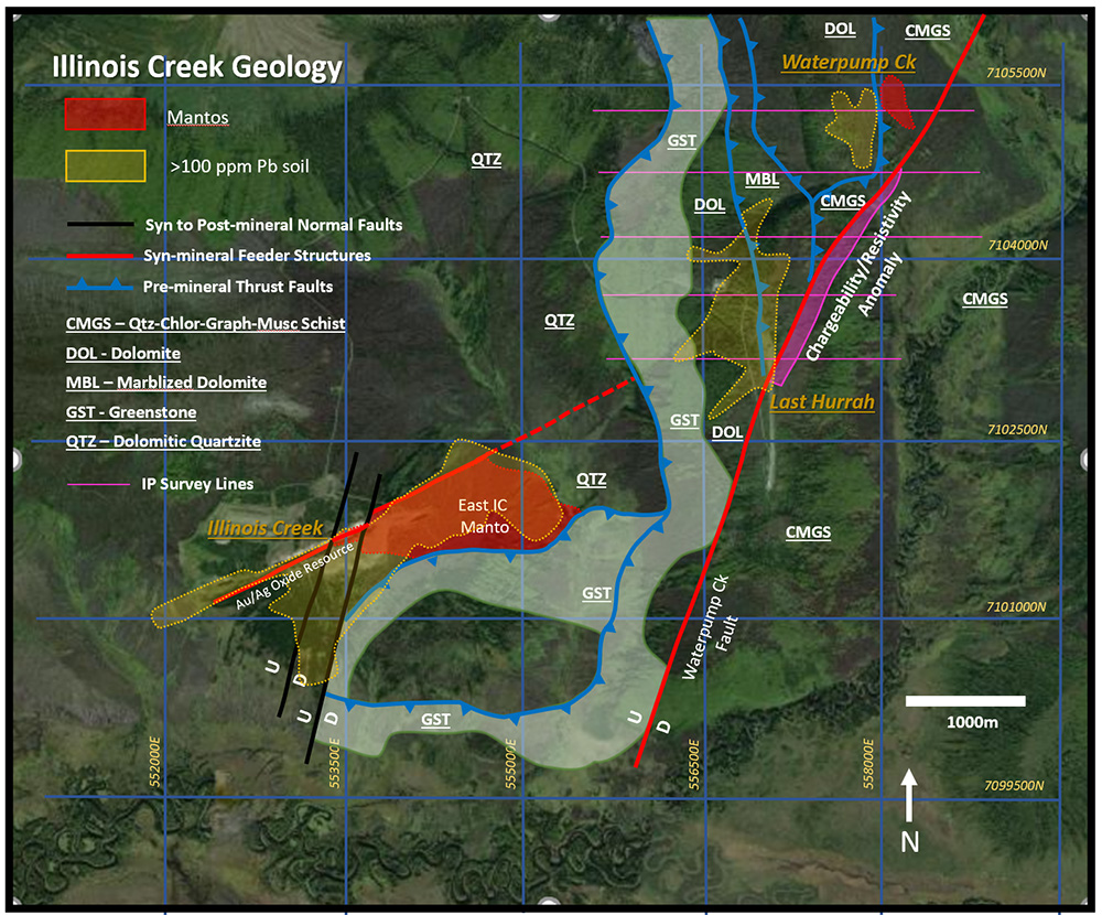
More specifically, manto mineralization appears to have developed at or near syn-mineral structures and thrust contacts between; 1) overlying CMGS schists and dolomite, 2) a dolomitic marble with a basal chlorite schist and underlying dolomite, and 3) massive Triassic greenstone sills/dikes and underlying dolomitic quartzite.
Major exploration potential occurs along and near the intersections of the high-angle syn-mineral structures and the temporally earlier thrust faults. Significant potential for stacked mantos exist along the entire hanging-wall strike length of the Waterpump Creek fault below the overlying CMGS schists.
The qualified person who reviewed and approved the technical disclosure in this release is Stuart Morris, P. Geo., a qualified person as defined under NI43-101.
Quality Assurance/Quality Control of drill sample assay results have been independently monitored through a quality assurance/quality control (“QA/QC”) protocol which includes the insertion of blind standard reference materials, blanks, and duplicates at regular intervals.
Logging and sampling were completed at WAM’s core handling facilities located at the Illinois Creek mine camp in Alaska. Drill core was logged under an established procedure using Geospark commercial logging software, then diamond sawn on site. Half drill-core samples were securely transported to SGS Canada Inc. sample prep facilities in Whitehorse Yukon via air transport to Fairbanks, Alaska from Illinois creek and then commercial trucking to Whitehorse under a strict chain of custody protocol. Sample pulps were sent to SGS’s labs in Burnaby, Canada, for analysis. Gold content was determined by fire assay of a 30-gram charge with ICP finish. Silver, lead, copper, and zinc along with other elements were analyzed by ICP methods utilizing a four-acid digestion. Over-limit samples for silver, lead, copper, and zinc were determined by ore-grade analyses. SGS Canada Inc. is independent of Western Alaska Copper and Gold and its affiliates.
SGS also performed its own internal QA/QC procedures to assure the accuracy and integrity of results. Parameters for SGS’ internal and WAM’s external blind quality control samples were acceptable for the samples analyzed. WAM is unaware of any drilling, sampling, recovery, or other factors that could materially affect the accuracy or reliability of the data referred to herein.
About WAM
WAM recently began trading as a Tier 1 company listed on the TSX-V and maintains corporate offices in Alaska and Arizona. WAM has reassembled and fully controls all claims in the historic Illinois Creek Mining District located in western Alaska near the Yukon River, covering 49,280 acres (77 square miles). This significant district was originally discovered by Anaconda Minerals Co. in the early 1980's. Since 2010, WAM and its private precursory company Western Alaska Copper & Gold Inc. has been engaged in exploring and advancing its interests in the district and now controls a diversified portfolio of five deposits that contain gold, silver, copper, lead, and zinc.
On behalf of WAM
“Kit Marrs”
Kit Marrs
Chairman & CEO
For further information please contact:
Vanessa Bogaert, Director of Corporate Communications/IR at vanessa@westernalaskaminerals.com
Or visit our website at: www.westernalaskaminerals.com
Neither the TSX Venture Exchange nor its Regulation Services Provider (as that term is defined
in policies of the TSX Venture Exchange) accepts responsibility for the adequacy or accuracy of
this release.
Forward Looking Information
Certain statements made, and information contained herein may constitute "forward looking information" and "forward looking statements" within the meaning of applicable Canadian and United States securities legislation. These statements and information are based on facts currently available to the Company and there is no assurance that actual results will meet management's expectations. Forward-looking statements and information may be identified by such terms as "anticipates", "believes", "targets", "estimates", "plans", "expects", "may", "will", "could" or "would". Forward-looking statements and information contained herein are based on certain factors and assumptions regarding, among other things, the estimation of mineral resources and reserves, the realization of resource and reserve estimates, metal prices, taxation, the estimation, timing and amount of future exploration and development, capital and operating costs, the availability of financing, the receipt of regulatory approvals, environmental risks, title disputes and other matters. While the Company considers its assumptions to be reasonable as of the date hereof, forward-looking statements and information are not guaranteeing of future performance and readers should not place undue importance on such statements as actual events and results may differ materially from those described herein. The Company does not undertake to update any forward-looking statements or information except as may be required by applicable securities laws.