Western Alaska Minerals Extends Waterpump Creek Mineralization
TUCSON, ARIZONA, US – July 6, 2023 - Western Alaska Minerals (the "Company" or "WAM") (TSX-V: WAM) is pleased to report that 2023 drilling continues to hit thick, visually impressive multi-stage massive sulfides in initial step-out and infill holes on its 100% owned Waterpump Creek (“WPC”) Carbonate Replacement Deposit (“CRD”).
Highlights
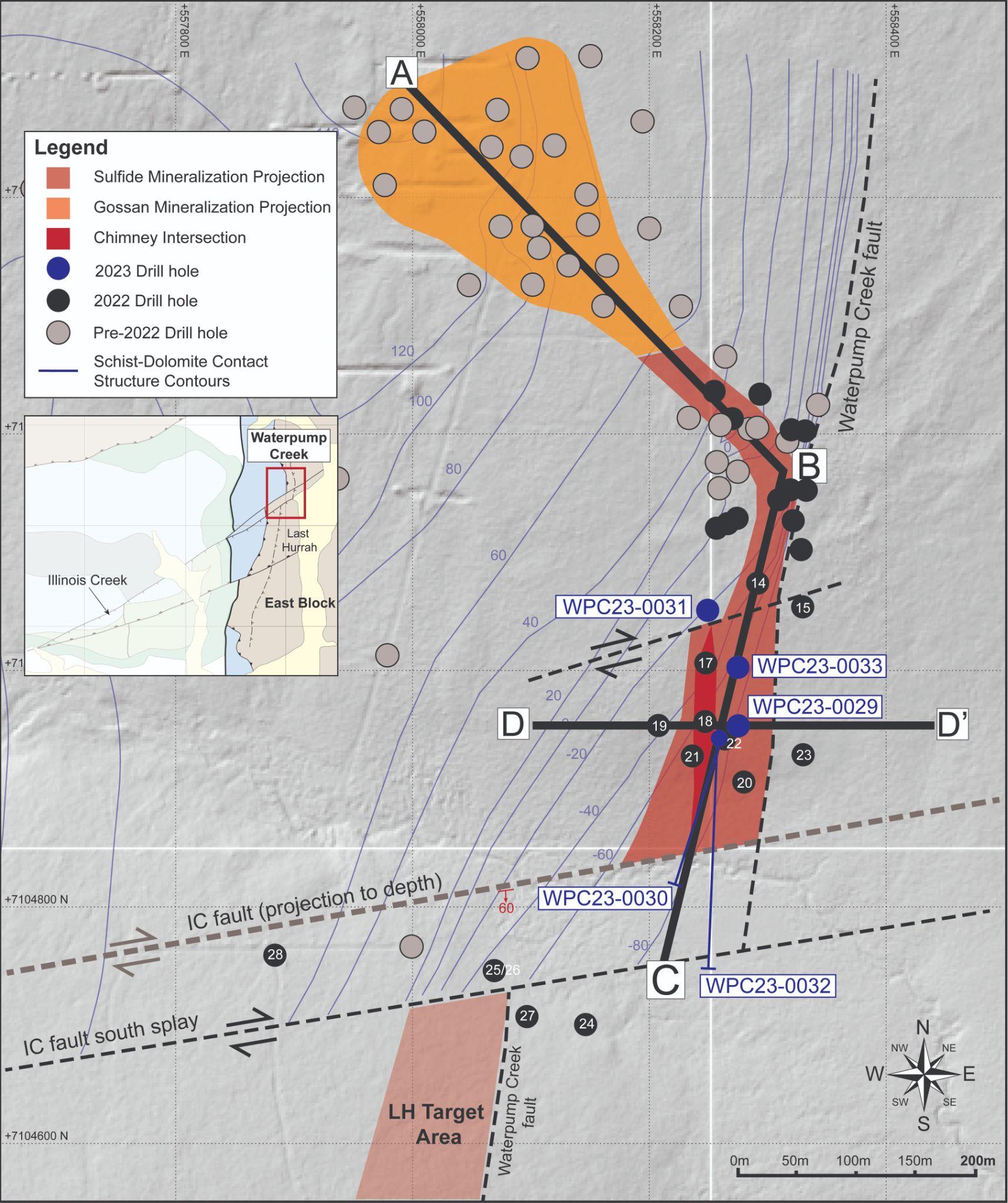
- Step-out drilling (see Figure 1):
- WPC23-0030: Two zones intersected (82.3m and 8.1m thick) of mixed base-metals sulfide and oxides.
- Extends WPC zone 45 meters south.
- WPC23-0032 confirms the location of the Illinois Creek fault, which potentially offsets the southerly continuation of the WPC-Last Hurrah mineralization trend to the west.
- WPC23-0030: Two zones intersected (82.3m and 8.1m thick) of mixed base-metals sulfide and oxides.
- Infill drilling (see Table 1):
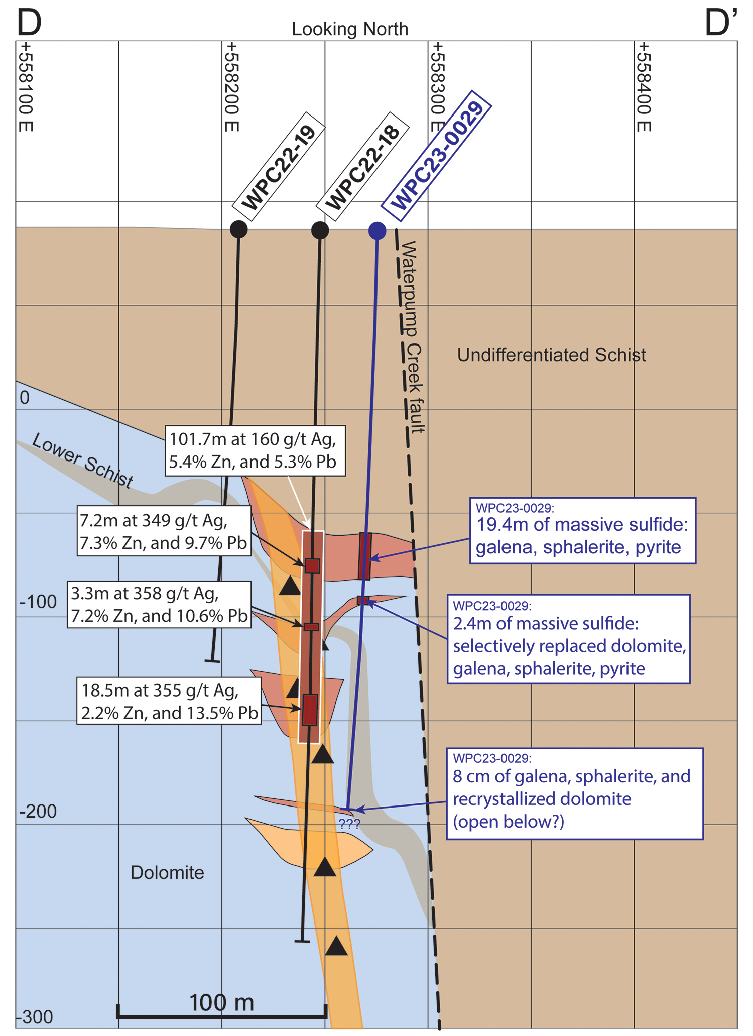
- WPC23-0029 intersected three zones (19.5m, 2.4m, and 2.1m thick) drilled 28m east of hole WPC22-18 (multiple high-grade zones intersected including 101.7m grading 160 g/t Ag, and 18.5m grading 355 g/t Ag).
- WPC23-0033 intersected one zone (6.1m thick), drilled 30m east of WPC22-17 (multiple high-grade zones intersected including 9.8m grading 428 g/t Ag, and 48.8m grading 144 g/t Ag).
Summary
Textures and mineralogy in holes WPC23-0029, WPC23-0030, and WPC23-0033 are visually similar and lie at comparable depths to the progression of silver-rich mineralized intercepts cut in 2022, indicating successful infill drilling and extension of the WPC body.
- Five holes have been drilled, totaling 1,706 meters.
- WPC23-0031 intersected a 3.1m oxidized zone from 160.3 to 163.4 meters with significant alteration to the dolomite host unit, further defining the western edge of the WPC mineralization.
- Two rigs are currently turning on the “Last Hurrah” target to the south, exploring for the fault offset of the Waterpump system.
- Full Waterpump Creek results and technical details can be found on the website.
“Overall, what we see in these holes confirms the continuity of the Waterpump Creek massive sulfide body. Notably, they also unveil its potential extension towards the south aligning with the ongoing direction of our drilling efforts.” said Kit Marrs, CEO of Western Alaska Minerals.
Table 1. Previously reported 2022 Drill intercepts of holes proximal to the 2023 Waterpump Creek infill holes.
| Drill Hole | From | To | Thickness | Ag | Ag | Zn | Pb |
| (meters) | (meters) | (meters) | g/t | Oz/t | % | % | |
| WPC22-17 | 125.5 | 174.3 | 48.8 | 144 | 4.6 | 9 | 5.5 |
| including | 125.5 | 135.3 | 9.8 | 428 | 13.8 | 15.9 | 14.1 |
| including | 160.6 | 164.7 | 4.1 | 417 | 13.4 | 14.8 | 18.3 |
| WPC22-18 | 147.2 | 248.9 | 101.7 | 160 | 5.1 | 5.4 | 5.3 |
| including | 158.6 | 165.8 | 7.2 | 349 | 11.2 | 7.3 | 9.7 |
| including | 191.7 | 195 | 3.3 | 358 | 11.5 | 7.2 | 10.6 |
| including | 223.8 | 242.3 | 18.5 | 355 | 10.8 | 2.2 | 13.5 |
| WPC22-20 | 166.6 | 178 | 11.4 | 284 | 9.1 | 14.8 | 10.9 |
| including | 166.6 | 175 | 8.4 | 322 | 10.6 | 12.1 | 12.8 |
| including | 166.6 | 168.2 | 1.6 | 474 | 15.2 | 24.7 | 14.3 |
| including | 173.9 | 175 | 1.1 | 883 | 28.4 | 12.2 | 45.2 |
| WPC22-20 | 185.2 | 205.9 | 20.7 | 171 | 5.5 | 9.4 | 5.8 |
| including | 187.8 | 189.7 | 1.9 | 272 | 8.7 | 22.3 | 7.6 |
| including | 193.4 | 196.1 | 2.7 | 297 | 9.5 | 2.8 | 10.6 |
| WPC22-22 | 161.6 | 184.3 | 22.7 | 293 | 9.4 | 9 | 20.3 |
| including | 161.6 | 168.6 | 7 | 557 | 17.9 | 16.7 | 21.8 |
| WPC22-22 | 207 | 216.5 | 9.5 | 118 | 3.8 | 3.5 | 8.7 |
| WPC22-22 | 245.7 | 300.3 | 54.6 | 187 | 6 | 6.2 | 5.1 |
| including | 271.1 | 274.6 | 3.5 | 1223 | 39.3 | 32.5 | 8.1 |
| including | 292.6 | 300.3 | 7.7 | 311 | 10 | 10.1 | 1.8 |
Extending the WPC Mineralized Zone
Three of the five holes intersected massive sulfide and mixed sulfide-oxide mineralization, apparently confirming and extending the known high-grade mineralized body (see Press Release of December 7, 2022) 45 meters south. The Company expects the assay results to allow for a future mineral resource estimate.
Targeting beyond Waterpump Creek
With the completion of these initial Waterpump Creek in-fill and step-out holes, the two drills on site are now exploring for the continuation of the Waterpump Creek mineralization across a post-mineral fault. The target is named “Last Hurrah.” The preliminary results of the ongoing 3D distributed array IP/resistivity (3DIP) geophysical survey are aiding our drill targeting at Last Hurrah (see “3D IP Survey and Inversion Modeling” section below).
Hole WPC23-0029 Highlights
- Located 28 meters east-southeast of hole WPC22-18, which cut 101.7m of massive and semi-massive sulfides grading 160 g/t Ag, 5.3% Pb, and 5.4% Zn and interpreted as a feeder chimney (see Press Release of September 22, 2022).
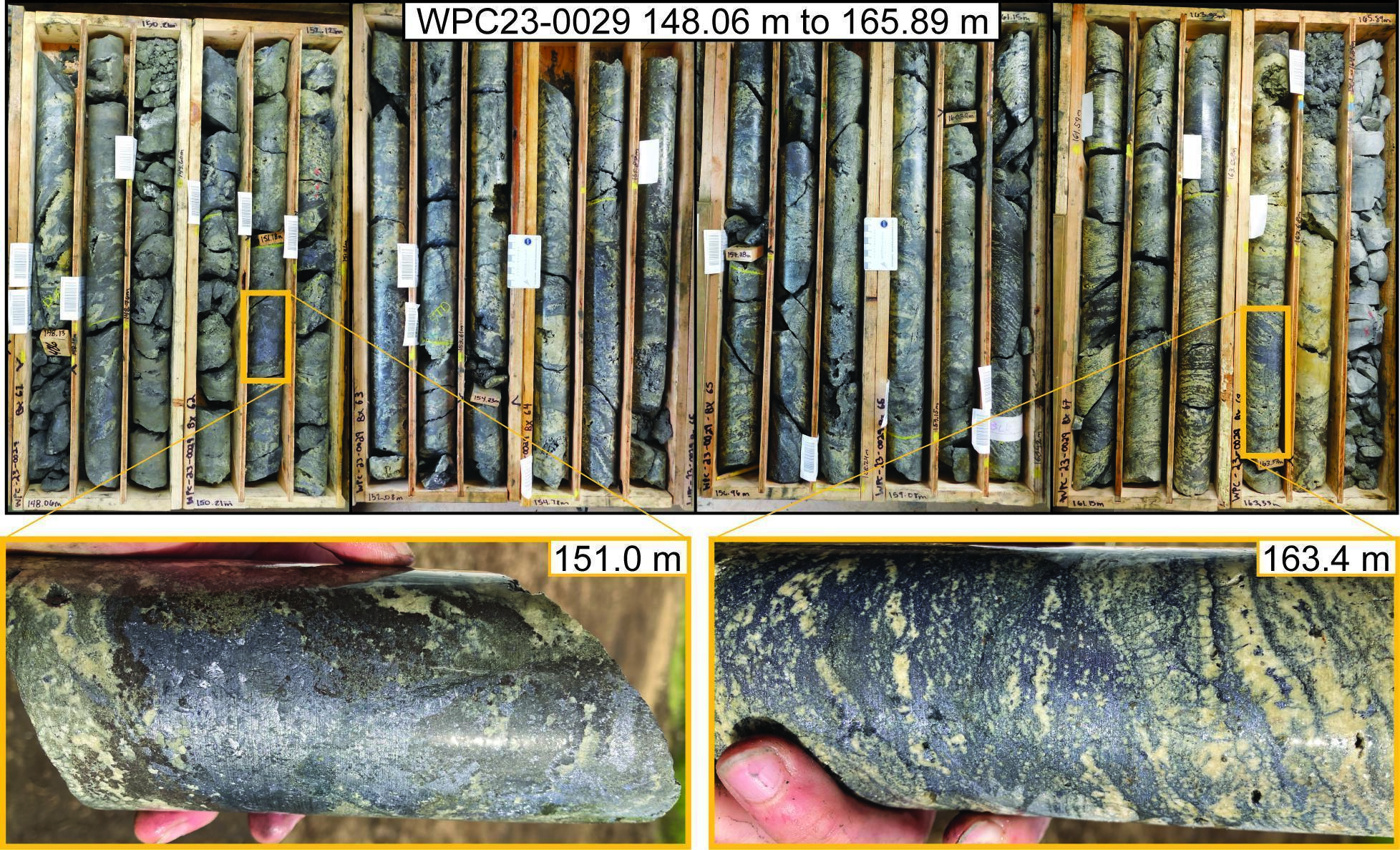
- Upper intercept (19.4m) visually resembles the high-grade zones in the interpreted WPC22-18 chimney (see Photo 1 below).
- All three intercepts show classic multi-phase CRD-style massive sulfide mineralization with multi-generation silver-rich galena, sphalerite, and pyrite mineralization phases.
- Similar mineralization has now been cut at similar elevations in 11 contiguous drill holes indicating a continuous elongate body 30 to 75 meters wide, now extended to 495 meters in length (See Figures 1 and 2).
- The hole ended in an 8 cm section of (open) mineralization, consisting of sphalerite and galena, hosted within recrystallized dolostone at 279.2 meters. At this point, the hole was lost, and it is unknown whether this mineralization continues at depth.
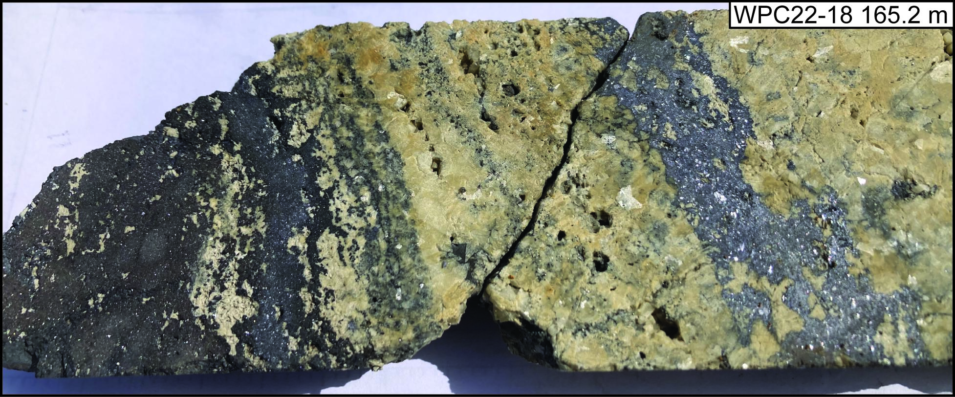
Photo 1. Core photos for the sulfide intercept in hole WPC23-0029 showing the entire length of the upper intercept from 145.08 to 164.54 and two close-up photos showing abundant galena and sphalerite mineralization in WPC23-0029 (top photos) compared to WPC22-018 (bottom photo).
Hole WPC23-0030 Highlights
- Collared from the same location as WPC22-22 and drilled at a -70° angle to the south-southwest to test the southern extent of the three zones of massive and semi-massive sulfides intersected in WPC22-22 (see Press Release of December 7, 2022 and assay results in Table 1 above).
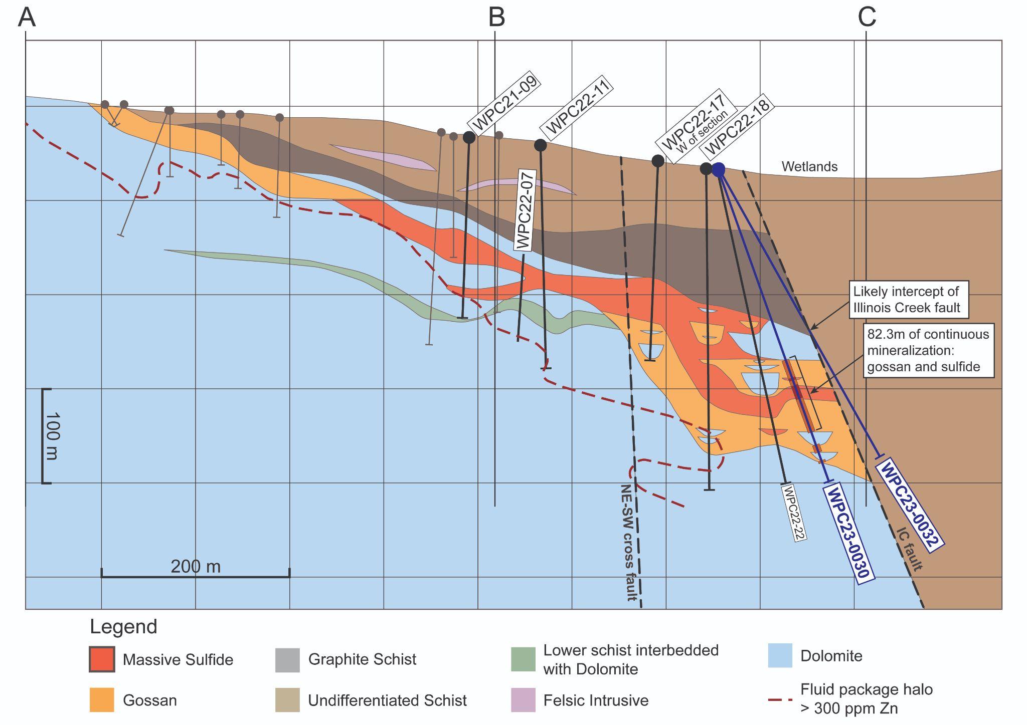
- Intersected continuous sulfide or gossan mineralization from 218.5 to 300.8 meters (82.3m). A lower gossan zone was cut from 316.1 to 324.2 meters (8.1m; Figure 2).
- The lower gossan intercept extends the known lower manto 45 meters farther south, giving a total strike length of CRD mineralization of 495m.
Hole WPC23-0033 Highlights
- Located 30 meters east of hole WPC22-17, which intersected 48.8m of massive and semi-massive sulfides grading 144 ppm Ag, 5.5% Pb, and 9.0% Zn (see Press Release of September 22, 2022 and Table 1).
- Intersected primary sulfide mineralization from 176.2 to 182.3 meters (inclusive of a 1.2m void) that includes 0.5 and 1.42m of massive sulfide replacement mineralization separated by 2.9m of dolostone laced with sulfide veins (see Photo 2).
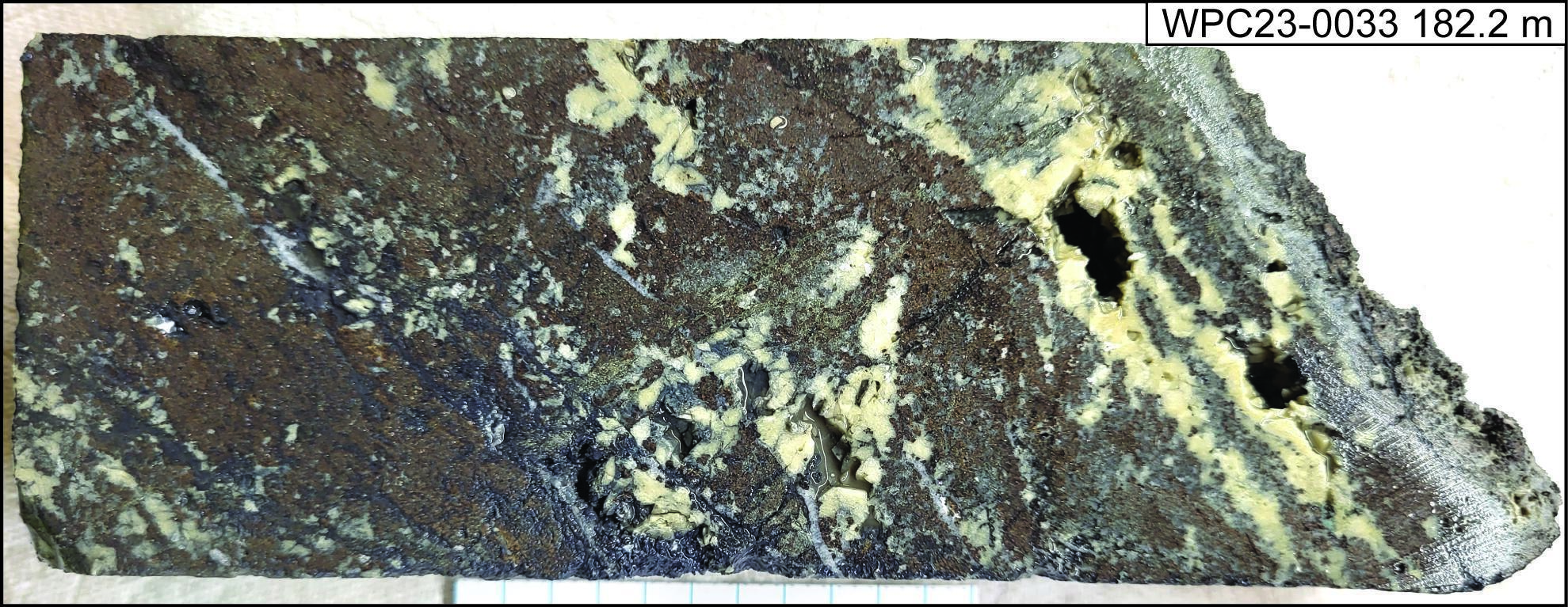
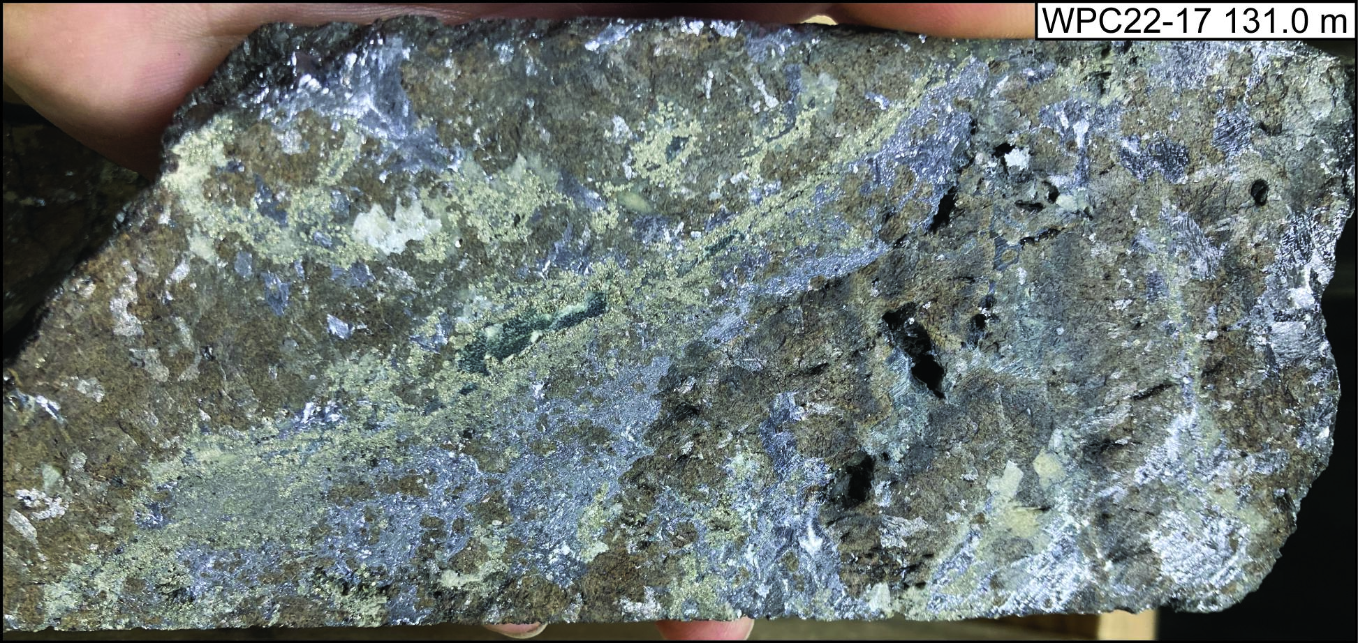
Photo 2. Core photo showing sphalerite and galena mineralization at 182.2m in WPC23-0033 (top photo) and similar mineralization at 131.0m in WPC22-17 (bottom photo).
Hole WPC23-0031
- Located 50 meters north of hole WPC22-17, which intersected 48.8m of massive and semi-massive sulfides (see Press Release of September 22, 2022).
- Cut altered wallrocks resemble those flanking massive sulfides along the axis of the WPC body.
Hole WPC23-0032
- Drilled from the same location as WPC23-0030 (and WPC22-22) at -60° to test south farther along strike of the WPC mineralization from WPC23-0030.
- Hit the Illinois Creek fault, which appears to have cut out the prospective carbonate stratigraphy (see Figure 1).
- The fault marks the southern edge of the WPC mineralized zone and supports targeting the offset mineralization at the Last Hurrah prospect.
Figure 1. Plan map displaying the 2023 completed drill holes in blue in relation to the expanding Waterpump Creek zone. Note the Last Hurrah (“LH”) Target Area in the offset fault.
The discussion below incorporates visual data from drill holes WPC23-0029, WPC-0030, and WPC23-0033 and comparisons to previous drilling for which assay results can be found on our website.
Mineralization Observations - Technical Discussion
Drill hole WPC23-0029 intersected two substantial zones of massive to semi-massive sphalerite and galena in a matrix of secondary dolomite similar to that reported in previous drilling press releases. The upper mineralized zone occurs from 145.1 to 164.5 meters which consists of galena, sphalerite, pyrite, and recrystallized carbonate (dolomite and ankerite). The ‘Zebra’ banded sulfide texture oscillates over 10’s of cm, with compositional bands of carbonate and sulfide, typically sphalerite dominant, ranging from 1 to 7 mm thick. Other textures are defined by open space replacement by multiple generations of sulfide. Sulfide occurrence is typically fine to medium-grained within coarse-grained carbonate gangue. Sphalerite color varies from a red-brown to a darker brown, indicating both occurrences are variably Fe-rich. Vertically oriented pyrite veins cut earlier sphalerite and galena mineralization indicating another later pulse of sulfide mineralization.
The lower sulfide intercept from 176.0 to 178.4 is dominated by fine-grained pyrite and sphalerite intergrown with up to 4 cm masses of galena. This zone is strongly structurally controlled as expressed by few vugs, lack of secondary recrystallized dolomite, and sulfides selectively replacing primary dolomite textures.
The intercepts are separated by altered and weakly mineralized to unmineralized dolomitic host rock, with veins of sphalerite, pyrite, and galena cutting the dolomite host. All the intercepts clearly show multiple cross-cutting stages of mineralization.
Figure 2. D-D’ Cross section displaying the drill trace for hole WPC23-0029.
Drill hole WPC23-0030 intersected 82.3m of continuous mineralization from 218.5m to 300.8m dominated by primary gossan, with zones of remnant galena and massive pyrite. A 2.8m zone from 238.6 to 241.4m consists of massive pyrite. A 15.2m zone from 246.9m to 262.1m consists of massive pyrite with galena and sphalerite. The lower section of mineralization from 262.1m to 300.8m is oxidized, but original calcite veins, galena bands exhibiting remnant carbonate replacement textures, and a small occurrence of Cu oxide remain. There are two smaller gossan zones downhole, which are separated by strongly altered fossiliferous dolomite. These gossan zones are 8.1m and 1.4m thick from 316.1m to 324.2m and 334.6 to 336.0m, respectively.
Figure 3. Long section looking east showing the lateral extent of the WPC zone and the 2023 step-off holes to the south.
Drill hole WPC23-0033 intercepted 55cm of massive sulfide mineralization at the upper dolomite contact beginning at 176.2m and 1.4m of banded sulfide replacement mineralization from 180.9 to 182.3m. Both intercepts consist of sphalerite, galena, and pyrite, displaying a banded zebra texture.
Waterpump Creek Drilling: Discussion
Combining the results of the 5 holes drilled in 2023 to the previous 26 holes drilled in the Waterpump Creek structural zone confirms continuous elongate ribbons (“mantos”) of massive sulfides 30 to 75 meters wide and 495 meters in length plunging gently to the south (Figures 1 and 2). The mineralization affects reactive dolomite lying beneath an impermeable schist along the WPC structure. Drill holes WPC23-0030 and WPC23-0032 tested the southern extension of the three mantos with high-grade silver-lead-zinc mineralization, previously intersected in WPC22-22, and extends those zones 45 meters farther south.
3DIP Survey and Inversion Modeling
The 3DIP geophysical survey operated by DIAS began on June 6th. IP acquisition is completed over this year’s exploration area of interest and 3D inversion modeling is in progress for targeting our next stage of drilling at Last Hurrah. The remaining portion of the 3DIP survey should be completed shortly with inversion modeling of the entire dataset to begin immediately.
Qualified Person
The qualified person who reviewed and approved the technical disclosure in this release is Andrew West, Certified Professional Geologist, a qualified person as defined under National Instrument 43-101. Mr. West is the Vice President for Western Alaska Minerals with a MS in Geology and 30 years of experience in mineral resources, mine, and exploration. He is a Certified Professional Geologist with the American Institute of Professional Geologists (AIPG CP-11759).
About WAM
WAM is an Alaska and Arizona based company, listed on the TSX-V and focused on discovery of high-grade, district-scale ore systems in the historic Illinois Creek Mining District located in western Alaska. WAM’s 100% owned claims cover 73,120 acres (114.25 square miles or 29,591 hectares), roughly 45 km from the Yukon River. The District encompasses at least five deposits containing gold, silver, copper, lead, and zinc and was originally discovered by Anaconda Minerals Co. in the early 1980's. Since 2010, WAM, along with precursor Western Alaska Copper & Gold Company, has reassembled the Anaconda property package and been engaged in exploring the District.
On behalf of the Company
“Kit Marrs”
Kit Marrs
President & CEO
Phone: 520-200-1667
For further information please contact:
Vanessa Bogaert, Director of Corporate Communications/IR at vanessa@westernalaskaminerals.com
Or visit our website at: www.westernalaskaminerals.com.
Forward Looking Information
Certain statements made, and information contained herein may constitute "forward looking information" and "forward looking statements" within the meaning of applicable Canadian and United States securities legislation. These statements and information are based on facts currently available to the Company and there is no assurance that actual results will meet management's expectations. Forward-looking statements and information may be identified by such terms as "anticipates", "believes", "targets", "estimates", "plans", "expects", "may", "will", "could" or "would". Forward-looking statements and information contained herein are based on certain factors and assumptions regarding, among other things, the estimation of mineral resources and reserves, the realization of resource and reserve estimates, metal prices, taxation, the estimation, timing and amount of future exploration and development, capital and operating costs, the availability of financing, the receipt of regulatory approvals, environmental risks, title disputes and other matters. While the Company considers its assumptions to be reasonable as of the date hereof, forward-looking statements and information are not guaranteeing of future performance and readers should not place undue importance on such statements as actual events and results may differ materially from those described herein. The Company does not undertake to update any forward-looking statements or information except as may be required by applicable securities laws.
Neither TSX Venture Exchange nor its Regulation Services Provider (as that term is defined in the policies of the TSX Venture Exchange) accepts responsibility for the adequacy or accuracy of this release.
